Could this be the most problematic section of the walk to plan ? It was certainly starting to look that way. It’s the longest section according to my initial carve up and with me needing to make sweeping assumptions about the daily distances I could make by predicting my fitness and the effect of any weather conditions. There’s not really much in the way of bricks and mortar between Abergavenny and Llandovery, unless you’re up for a detour off the route, and there are also some alternative routes to consider. And all this in order to make an overall northerly distance gain of 12½ miles. So it’s no wonder that after my initial burst of enthusiasm in planning the first stage, my willingness to tackle the second dissipated somewhat.
Initial Thoughts
Yes, you did read correctly – I checked the grid lines on the map and Llandovery is about 12½ miles (i.e. 20 grid squares of 1km) north of Abergavenny. But a long way to the west, which is what eats up most of the walking time. Indeed the north bit is easy as the mountains of the Brecon Beacons generally have ridges and valleys extending north-south. Or in other words that westwards walk is going to involve a lot of up and down, which is borne out by the stats for this section – 74 miles (119km), 16,640 feet (5,072m) of ascent and 7 days effort, based on the rough tot up from the figures in the book.
The only place of any size midway through this rollercoaster of hills is Brecon and that’s a bit too far off route and involves a big descent which would have to be regained in some form. So I’m reliant for re-supply on the smaller villages with Crickhowell, Ystradfellte and Glyntawe looking the most likely. Chuck in a number of pink triangles and squares on the map (i.e. youth hostels and bunkhouses) and there seem to be a lot of decisions that need to be made for this section. And that’s before I gen up on the status of those hostels and bunkhouses, as I know from reading people’s accounts that these keep shutting – I just haven’t worked out yet which ones they are.
Cutting the Corner ?
Throw in also, the so-called “bee-liner’s” problem. With Crickhowell just up the road from Abergavenny (you could be there well before lunch), but not actually arrived at until two long days walking through the Black Mountains, there’s the question of cutting the corner off, and Tony Drake discusses this in his book. Whilst I’ve done part of the Black Mountains before, so will be repeating some mountains, it does seem wrong to even contemplate cutting the corner. Indeed, Tony’s made it difficult by including no less than 5 checkpoints on this stretch, all of which would be missed if you cut the corner. And according to Tony’s book, no checkpoints = no Cambrian Way completion. I’m not going to cut the corner, as there’s no point setting out to walk the Cambrian Way and then to deliberately miss out a sizeable chunk. But also because I’d also be passing up all of the juvenile humour opportunities afforded by a visit to Twmpa:
Access
Then to compound it all, there’s uncertainty over the route that passes over Fan Nedd and Fan Gyhirych. I can’t find up to date information on the status of this part of the route. It’s part of the Cnewr Estate which in years gone by used to ban access totally due to the fact that their sheep had to lamb on the hill. This then became a permissive path which then became normal open access with the advent of CRoW. But I’ve seen suggestions that the route is still closed during lambing season (guess when my walk is pencilled in for!), and I know that farmers do have the ability to close their land for certain purposes and a certain number of days per year. Even Cnewr’s roadside campsite is closed during lambing. So all of this leaves me unsure about this part of the route. There is an easy way to neutralise the Cnewr question, which is to follow the so-called Ystradfellte variant and avoid these moors altogether. Even the oracle of George Tod, three-time walker of the Cambrian Way, isn’t much help here as he took the Ystradfellte variant anyway for accommodation purposes. But it might also afford an opportunity for re-supply and a night off from camping (I’d ideally like one in the middle of this 7 day stretch). So the key decision I need to make here is whether to plan to take the variant route, or plan on the higher level route but be prepared to change my plans on the hoof.
So I went into the detailed planning for this chunk, thinking it would come down to my re-supply plan for this section, and with a working assumption that I probably would take the Ystradfellte variant.
What is clear, however, is that this is where the walk starts getting interesting, leaving civilization behind and bringing on the big scenery. One thing’s pretty clear – I’ll either arrive in Llandovery fired up for the rest of the walk, or crawl into Llandovery with my tail between my legs. I suspect the weather may play a not insignificant part in this outcome.
The Draft Plan
And I mean draft, as the number of variables thrown into this mean there’s a reasonably high likelihood of changes during the rest of the preparation for the walk, let alone any changes that could arise when actually on the walk itself.
My first attempt, based on an old “what if” route plan that I did a couple of years ago, backed up the original estimate of 7 days – largely because at that time finding bricks and mortar accommodation each night was the only approach being considered. This meant extra miles at the start and end of most days to pick up the various hostels and bunkhouses. Most of these diversions disappeared last night when I sat down to do the plan properly.
My first go was coming out with days of 14-15 miles pretty consistently each day but this then left with me with an arduous 19 miler on day 6 because of the desire to have some proper accommodation in Llandovery. Since this also had over 1,200m of ascent I felt this was beyond my capabilities, working out at nearly 27 miles of equivalent flat walking using my usual formula. Of course I could have just stopped short of Llandovery and wild camped, but this effectively meant passing up on a proper wash, an intensive gadget recharge, and a beer – the timings wouldn’t have really worked for these if passing through Llandovery mid-morning. So I then looked again to see if I could shorten the last day of this section by moving some of the mileage back through preceeding days. I managed to do this only going back as far as day 4 of 6.
I was also surprised that this section worked out at 88 miles compared with 74 in the book, because I’m also plotting my route with a downloaded gpx file of the Cambrian Way from the LDWA website members’ area on screen. I haven’t quite worked it out, but it is what it is.
So, as the diagram is pretty busy, here’s the plan in words. [Once again, photos are © George Tod, who allows their non-commercial use].
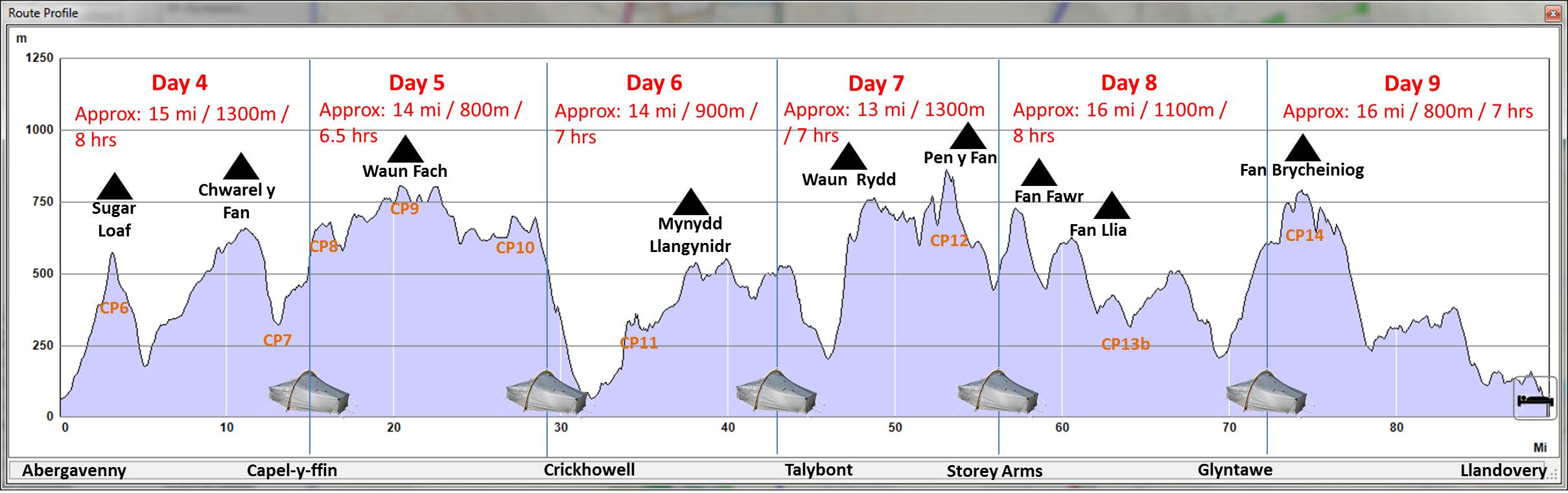
I’ll leave Llandovery, climb Sugar Loaf and then head into the Black Mountains proper, climbing up onto Chwarel y Fan before dropping down to Capel-y-ffin. Night 1 of this section (night 4 overall) is targetted to be the first decent wild camp spot I find on the way up out of Capel-y-ffin.

On day 2 (5), I’ll finish the ascent of Twmpa or Lord Hereford’s Knob (see above) and then head over Rhos Dirion to the Waun Fach ridge stopping short of Crickhowell for an overnight pitch on the way down.

Hopefully a decent breakfast in Crickhowell will set me on my way for the lower level walking and then final climb over Mynydd Llangynidr to find night 3’s pitch somewhere above the Talybont reservoir.

On day 4 (7), it’s all about a traverse of pretty much the whole Pen y Fan group, pushing as far as I can get to help out on the distances for the next two days, but assumed for now that the overnight will be the other side of the A470.

Day 5 (8) is the day of route choice, and I’ve assumed for now that it will be over Fan Fawr and Fan Llia, descending to Blaen-nedd-isaf and heading around to Glyntawe. In order to help my legs for the final day’s push on this section, I need to make a couple of miles the other side of Glyntawe before bedding down.

The sixth and last day (day 9 overall) of this section is all about Fan Brycheiniog, which has long been on my to do list, being one of the Trail 100s.

It’s just a bit of a pity that the walk out to Llandovery is quite long. But that night in Llandovery is all about reward for accomplishing the whole of the southern section, and in particular the part of the walk that I had most concerns about. So there will be a splurge on decent food and ale, I’m sure. This will be one of those rare B&B nights on this walk, and because there are so few of them the price is almost irrelevant. I just hope wherever I book has enough sockets for all of the charging I’m going to need to do!
Checkpoints and Hills
There are 9 checkpoints on this stage:
- CP6 – Sugar Loaf
- CP7 –Capel-y-ffin
- CP8 – Twmpa
- CP9 – Waun Fach
- CP10 – Pen Allt Mawr
- CP11 – Eglwys Faen
- CP12 – Pen y Fan
- CP13 – Blaen-nedd-isaf junction (or Fan Gihirych if a higher level route were to be taken)
- CP14 – Fan Brycheiniog
If I follow the route as planned, then I’ll also pass over the following hills (* indicates those already bagged on previous walks):
- Sugar Loaf (596m, Marilyn, Dewey, Trail 100)
- Chwarel y Fan (679m, Hewitt, Nuttall, County Top)*
- Twmpa (680m, Hewitt, Nuttall)*
- Rhos Dirion (713m, Nuttall)*
- Waun Fach (811m, Marilyn, Hewitt, Nuttall)
- Pen y Gadair Fawr (800m, Hewitt, Nuttall) – a short detour needed
- Mynydd Llysiau (663m, Hewitt, Nuttall)
- Pen Twyn Glas (646m, Nuttall)
- Pen Allt-mawr (Hewitt, Nuttall, HuMP)
- Pen Cerrig-calch (701m, Hewitt, Nuttall)
- Mynydd Llangynidr (557m, Dewey, HuMP)
- Bryniau Gleision (538m, Dewey)
- Allt Lwyd (654m, Nuttall)
- Waun Rydd (769m, Marilyn, Hewitt, Nuttall)
- Bwlch y Ddwyallt (754m, Nuttall)
- Craig Cwareli (730m, deleted Nuttall)
- Fan y Big (719m, Hewitt, Nuttall)*
- Cribyn (795m, Hewitt, Nuttall, HuMP)*
- Pen y Fan (886m, Marilyn, Hewitt, Nuttall, Trail 100, County Top)*
- Corn Du (873m, Nuttall)*
- Y Gryn (619m, Nuttall)
- Fan Fawr (734m, Marilyn, Hewitt, Nuttall)
- Fan Llia (632m, Hewitt, Nuttall)
- Fan Hir (761m, Hewitt, Nuttall)
- Fan Brycheiniog (802m, Marilyn, Hewitt, Nuttall, Trail 100)
- Picws Du (749m, Hewitt, Nuttall)
- Waun Lefrith (677m, Nuttall)
This list will make a big contribution to my hills count, adding 2 Trail 100s, 16 Nuttalls (of which 11 are Hewitts) and 5 Marilyns. Were I to take the Cnewr estate route, then I would drop Fan Llia and replace with Fan Nedd, Fan Fraith and Fan Gyhirych all of which are Nuttalls and two of them being Marilyns and Hewitts. This will very much be a decision on the day.
Final Thoughts
Although I’m sure the plan will evolve for this section, quite possibly even out on the hill itself, I’ve now got a plan to work from, and feel a lot better than I did at the start. Plotting the route over these big hills and looking at George Tod’s pictures has got me excited about this part of the route, and I want to be out there now. Indeed my trepidation was so bad beforehand that one look at the map and stats and I almost decided there and then to break the whole walk in two – it just couldn’t be shortened to a viable 3 week schedule. But now I’ve shaved a day off, albeit at the cost of some consecutive hard days walking, all of which is within my capabilities, and I’ve got inspired by the terrain and the sweeping views I should, weather permitting, get. And you know what, even if I stopped the whole walk in Llandovery, it would still be well worth doing.
This section is “my home” so to speak as I have yomped these hils for countless years and they still excite me even now. You will really enjoy this section and although resupply needs careful consideration its not impossible.
I’ll have a look at your route and suggest a few good wildcamp spots if you want?
LikeLike
Please do, more than happy to have a bit of local expertise. I’ve worked some out based on what looks like flattish ground with shelter if needed, but I’d much rather have some spots in mind that I know will be decent. You can probably work out roughly where mine are from my description and route profile 😉
LikeLike
Indeed, I can send you my gpx if you want ?
LikeLike